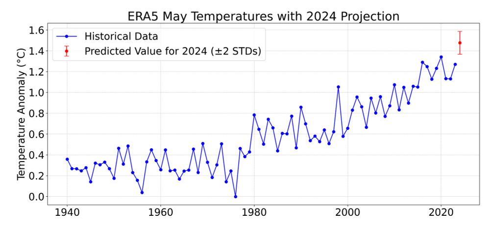
With half the month of data in, its very likely (>95% chance) that May 2024 will be the warmest May on record, extending the streak of record breaking months to 12 in a row:
If this trend continues, global temperatures will likely fall out of record territory in June.
But we still don't fully understand the exceptional warmth in the second half of 2023, so any predictions at this point should be treated cautiously. theclimatebrink.com/p/2023s-unex...
current marine heatwave state - I included last year and this year date of yesterday - I really wonder how many more years I have to wait till one study declares the non-linear expansion of MHWs a feedback that speeds up global warming-most causes point in this direction - each region different mix
Marine heatwaves are stronger currently than last year in the Southern Ocean - bad sign as Antarctic sea ice is larger than last year. Indian Ocean way warmer than last year. Southern and Northern Atlantic and Northern Pacific quite similar. Of interest will be how La Nina will influence NH MHW's...
making progress. But in any case, humanity should prepare for the next temperature jump as extremes are further increasing non linear all over the place in all their forms - flooding and their counterpart heatwaves are just nuts currently with the storm season coming around the corner.
So it will be of interest how long the just building up La Nina will last as the tropical Pacific is far from being discharged in terms of warm water - currently near neutral just on the brink to recharge again. Further, the current La Nina has problems to develop - tropical instability wave slowly
But I guess the current temperature jump is over but the next one will likely be larger as they grow in size as more systems push them. What is of interest here that the tropical Atlantic is now starting to cool - but a warmer tropical Atlantic (Nino) supports La Nina.
Also a question is if warming in the pipeline being released from the ocean will get another round this year - warm water masses accumulating in several regions in the subsurface oceans - some signals of ocean heat release we already had - so interesting if we will get other signals the coming years
Also as marine heatwaves are currently much lower than at their maximum extent last year of more than 40% absorbed shortwave radiation went down substantially the last months- so if MHWs area goes up again during this summer SW absorption should go up again.
warming. As we had an increase of water vapor the last months by more than 5% could mean that continental heat waves are a little counteracted by large scale flooding. But convection also provides lots of hot air for high pressure systems - ocean areas above 28°C currently at highest area extent.
As the marine heatwaves are a feedback of global warming the oceans too fast and the pattern effect on circulation thermal stratification especially over the first 300m going last year through the roof was a really bad signal. Main question here: how the single MHW regions can force each other into