Tim Supinie

Profile banner

Tim Supinie

@plustssn.bsky.social

Hydrometeor connoisseur 💧❄️🌪️ / Electron herder 💻 / Rhythmic airbender 🎸🎶 / Amateur edible chemist 🍞🍳 / Heather's worse half 👫 / OU SoM alum 👨‍🎓
Avatar
I'm really gonna have to rethink my relationship with social media for the next 4 months. (At least.)
Reposted byAvatar Tim Supinie
Avatar
How accurate is the weather forecast in your city? Niko Kommenda and I learned that NWS just began doing gridded assessments of forecast accuracy. We got the data and mapped of how many days into the future they get within 3°F of the observed high temp. www.washingtonpost.com/climate-envi...
Reposted byAvatar Tim Supinie
Avatar
BREAKING: Hurricane #Beryl becomes the earliest Category 5 on record in the Atlantic basin.
Avatar
More autumnplot-gl stuff. I've reworked the colormaps internally to make it easier to apply colormaps to more plot types. So here are wind barbs colored by magnitude.
Avatar
Breaking early-season activity records from 1933 and 2005 certainly isn't what you want to see.
Hurricane #Beryl now has the distinction of being the earliest Category 4 hurricane on record in the Atlantic basin. Strengthening continues.
Reposted byAvatar Tim Supinie
Avatar
#Beryl lookin' about perfect on visible satellite. June!
Reposted byAvatar Tim Supinie
Avatar
Hurricane #Beryl now has the distinction of being the earliest Category 4 hurricane on record in the Atlantic basin. Strengthening continues.
Reposted byAvatar Tim Supinie
Avatar
Bad Map Projection: Exterior Kansas xkcd.com/2951
Avatar
Sunset storm north of the OKC metro earlier this evening.
Avatar
Probably the final presentation for these images unless I decide to do bootstraps or something. I moved the bars to the center of the hour to reflect electricity consumption occurring over the hour, not at the top of the hour. I also shaded alternating hours to help visually group the bars.
Playing around with our electricity usage data from the last 3 years. A/C switches to evening cool mode at 7pm. The laundry bump on weekends is also apparent (A/C program is the same on weekdays and weekends).
Avatar
Playing around with our electricity usage data from the last 3 years. A/C switches to evening cool mode at 7pm. The laundry bump on weekends is also apparent (A/C program is the same on weekdays and weekends).
Reposted byAvatar Tim Supinie
Avatar
Would you like to be my coworker? 🌎 EMC is looking for a Physical Scientist (GS-13/14) to lead the verification and evaluation of subseasonal and seasonal environmental modeling systems. The position is accepting applications from June 6 to June 20 🌐: www.usajobs.gov/job/794476800
Physical Scientistwww.usajobs.gov <p><strong>This is a Direct Hire Public Notice. Please read this Public Notice in its entirety prior to submitting your application for consideration.</strong><br> <br> This position is located within...
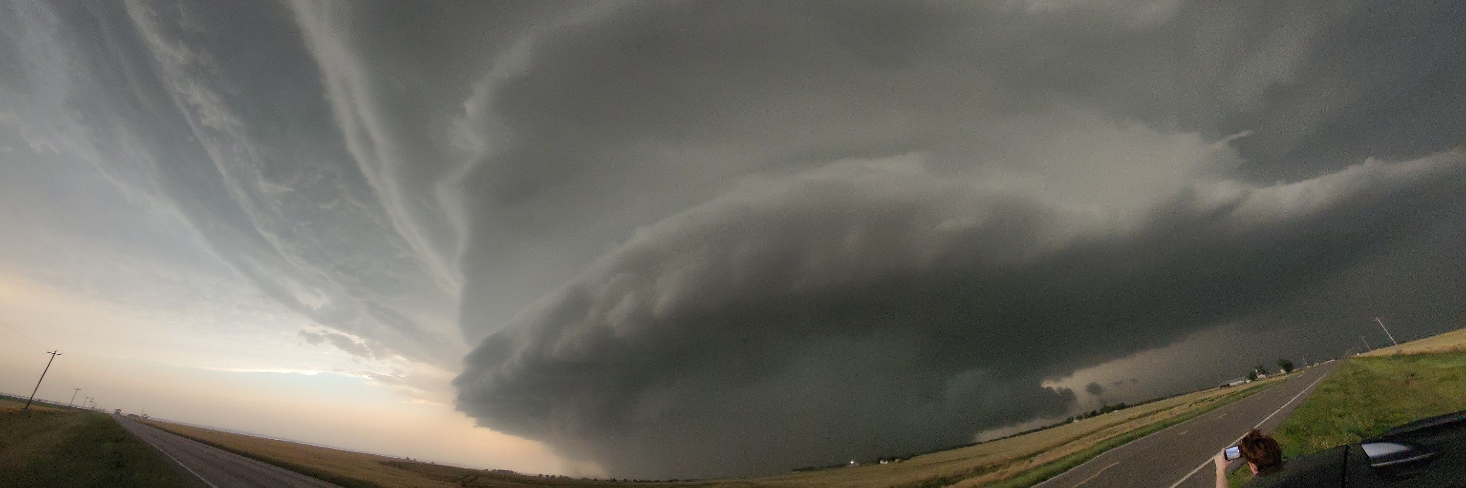
Reposted byAvatar Tim Supinie
Avatar
Jack Hales served as lead forecaster for SPC for 36 years, until his retirement in 2011. Here he is center, with Steve Corfidi (left) and Bob Johns (right) in 1984 (via Wikipedia). What a life.
Those of us who forecast monsoon weather in Arizona owe a lot to Jack Hales (June 11, 1942 ~ May 20, 2024). www.schwabmortuary.com/obituary/Joh... #azwx
Avatar
Well, that hodograph explains some things. Didn't expect to see 3 km AGL winds out of the southwest at 20 kts on the evening sounding.
Avatar
The HRRR has this environment in central OK this evening with cells moving in ... but they're left movers (split from convection in TX when the hodographs are straighter). I'm guessing those would be a mondo hail threat and not so much a tornado threat. Not sure it would play out like that, though.
Avatar
After tomorrow's high-end tornado threat to the I-35 corridor in OK (the third in the last month), I'm ready for northwest flow MCS season.
Well this was a helluva HRRR run to start the day off with. #okwx
Avatar
Avatar
Also, closer to home, lots of boundaries visible from KTLX. Based on Oklahoma Mesonet obs, the front either has stalled or will probably stall soon in southwest OK. It should continue to push eastward in eastern OK for a bit longer.
Avatar
Cold fronts are an unusual forcing mechanism for big tornado events due to 1) typically unfavorable boundary orientation and 2) strong mesoscale lift. Today seems to be an exception with a favorable boundary orientation in IA and storms moving quickly out of the zone of ascent.
Avatar
One of my favorite shots this evening east of Roll, OK. We probably didn't see the tornado near Custer City (too far east at the time).
Avatar
I've released autumnplot-gl v3.0. Major changes: * Added contour label support * Added an `addField()` function to make it easier to keep data in CPU RAM when it's not being displayed * Added overflow and underflow colors to the color bar * Various bug fixes github.com/tsupinie/aut...
Avatar
In the HWT Spring Forecasting Experiment this year, we're evaluating some of the new AI models like GraphCast, Pangu Weather, and FourCastNet with the GFS. Specifically, we're looking at 500 mb patterns conducive to severe weather on day 7. The comparison is here: hwt.nssl.noaa.gov/sfe_viewer/2...
Avatar
Late brunch of pancakes and blackberry syrup.
Avatar
Probably the best aurora shot I got with my phone at Canton Lake, OK this evening. @climbingfox.bsky.social probably got some better ones with her DLSR.
Avatar
Or 3) 🤷‍♂️ I'm not going to use the "b" word, but clearly things didn't go as expected. I have some guesses. I'm not sure it can be traced back to a single thing wrong, but several independent things. I might think on this a little more and come up with some supporting graphics in a few days.
Failure modes: there are a few, though I'm not sure they're likely. 1) Linear convective mode in KS. This is a failure mode shown by many CAMs this evening, though I'm not sure why. The shear vector orientation to the dryline fits the 45° rule of the thumb over the southern half of the state.
Reposted byAvatar Tim Supinie
Avatar
High risk inbound for the tornado threat in OK/KS today. www.spc.noaa.gov/products/md/...
Avatar
Well, every member of the 00Z HREF producing a giant UH swath somewhere in OK is less than ideal. I have a feeling the highest storm coverage is going to be from roughly Enid-ish northward, but I also bet someone near or south of I-40 gets extremely unlucky tomorrow night.
Avatar
About a week ago, our paper about Tornado Archive was accepted for publication in BAMS. Read it here in early online release: journals.ametsoc.org/view/journal...
journals.ametsoc.org
Avatar
500 mb patterns don't make a forecast, but man, these two are strikingly similar.
Reposted byAvatar Tim Supinie
A rose by any other name is out in final form. Fun with 3 elements of the 2x2 table. With Monte Flora and Mike Baldwin. One typo inserted by technical editor. Should a paragraph break before the last two sentences of abstract. journals.ametsoc.org/view/journal...
journals.ametsoc.org